|
Our paper entitled "Understanding American public support for COVID-19 risk mitigation: The role of political orientation, socio-demographic characteristics, personal concern, and experience" has been published the International Journal of Public Health (Impact factor: 3.38). Below please find the abstract:
"Objectives: COVID-19 is the most challenging public health crisis in decades in the United States. It is imperative to enforce social distancing rules before any safe and effective vaccines are widely available. Policies without public support are destined to fail. This study aims to reveal factors that determine the American public support for six mitigation measures (e.g., cancel gatherings, close schools, restrict non-essential travel). Methods: Based on a nationally representative survey, this study uses Structural Equation Modelling to reveal the relationships between various factors and public support for COVID-19 mitigation. Results: 1). Democrats are more likely than Republicans to support mitigation measures; 2).Favorability towards the political leader (Biden or Trump) can slant public support for COVID-19 mitigation measures among different segments of the public; 3). Indirect experience, rather than direct experience with COVID-19 can motivate people to support mitigation; 4). Concern for COVID-19 is a strong motivator of support for mitigation. Conclusion: Political polarization poses an enormous challenge to societal well-being during a pandemic. Indirect experience renders COVID-19 an imminent threat."
0 Comments
Our new paper entitled "Understanding the effects of individual and state-level factors on American public response to COVID-19" has been accepted for publication in American Journal of Health Promotion (Impact factor: 2.87). Below please find the abstract: "Purpose: To examine multilevel predictors on American public response to COVID–19. Design: Multilevel study. Setting: A national survey was conducted by Qualtrics from August 24 to September 11, 2020. The state-level variables were constructed on data from multiple sources. Subjects: 2,440 respondents 18 years and older from all 50 states and D.C. Measures: The outcome variable is the public response to COVID–19 measured by threat perception, behavioral adjustment, and policy support. The predictors include individual-level sociodemographic factors and state-level indicators about public health conditions, political context, and economic recovery. Analysis: Multilevel structural equation modeling is used for statistical estimation. Results: People from states with more COVID–19 cases (β=0.020, p<0.1), mandatory face mask policies (β=0.069, p<0.05), and liberal governments (β=0.002, p<0.05) are more likely to respond while people from states whose economies have recovered closer to the pre-pandemic level are less likely to do so (β=-0.005, p<0.05). Regarding individual-level predictors, older people (β=0.005, p<0.001) and people with better education (β=0.029, p<0.01), leaning toward the Democrat Party (β=0.066, p<0.001) and liberal political ideology (β=0.094, p<0.001), and have stronger generalized trust (β=0.033, p<0.001) are more likely to respond than their counterparts. Conclusion: Differences in the public response to the pandemic stem from variations in individual characteristics and contextual factors of states where people live. These findings contribute to the rapidly growing literature and have implications for public health policies."  Figure 1. Multilevel Structural Equation Modeling Diagram (Hao and Shao 2021b) 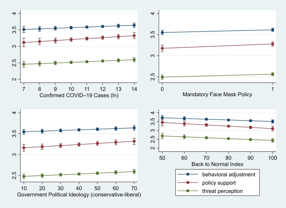 Figure 2. The Influence of State-Level Factors on Public Response to COVID–19 (Hao and Shao 2021b) 2/15/2021 0 Comments Our new paper in Health and Place Our new paper entitled "Understanding the influence of contextual factors and individual social capital on American public mask wearing in response to COVID-19" has been published in Health and Place (Impact Factor: 4.078) . Below please find the abstract: "The COVID–19 pandemic poses unprecedented risks to the health and well-being of the entire population in the U.S. To control the pandemic, it is imperative for individuals to take precautionary behaviors (e.g., wearing a mask, keeping social distance, washing hands frequently, etc.). The factors that influence individual behavioral response thus warrants a close examination. Using survey data for respondents from 10 states merged with state-level data, our study represents a pioneering effort to reveal contextual and individual social capital factors that explain public mask wearing in response to COVID–19. Findings of logistic multilevel regression show that the COVID–19 death rate and political control of government at the state level along with one’s social capital at the individual level altogether influence whether people decide to wear face masks. These findings contribute to the rapidly growing literature and have policy implications for mitigating the pandemic’s devastating impact on the American public." 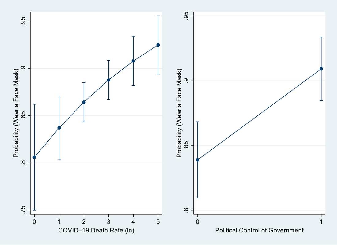 Fig. 2. Estimated Odds of Wearing a Face Mask predicted by State-Level COVID–19 Death Rate and Political Control of Government (Hao et al. 2021) 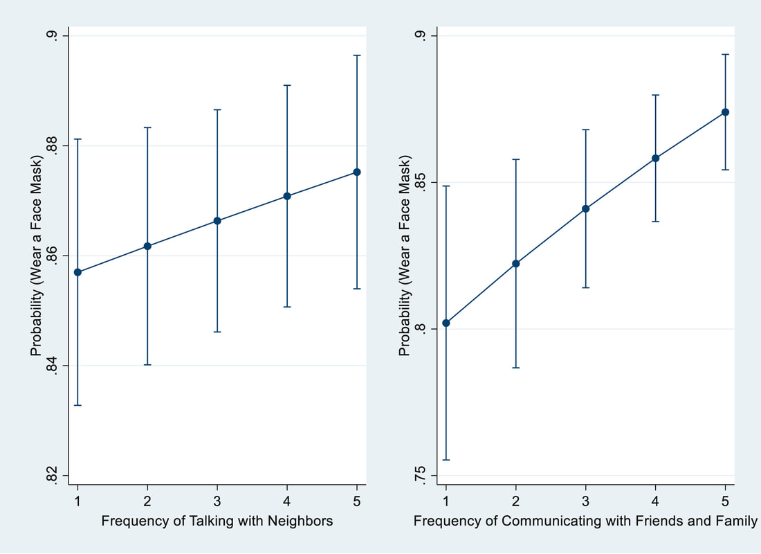 Fig. 3. Estimated Odds of Wearing a Face Mask predicted by Social Capital Indicators (Hao et al. 2021). 10/13/2020 1 Comment My analysis article on the Conversation I just published one analysis article on the Conversation. Below please find the last section:
"Hope for shrinking the power of misinformation The success of slowing the spread of COVID-19 hinges largely on people taking precautions, particularly wearing face masks and social distancing, until a safe and effective vaccine is widely available. One study on attitudes toward climate change offers some hope. It found that a large number of Republicans and conservatives actually hold more unstable views about climate change over time. This instability may mean they could be more open to listening to the evidence and changing their minds. If this is also the case with COVID-19, strategic science communications and community engagement activities may be able to make a difference and stop the rising death toll." Our new paper on perceptions of sea level rise has been published in Climatic Change (Impact factor: 4.743). Below please find the abstract: "Sea level rise (SLR) in the 21st century poses fundamental risks to coastal residents. The U.S. Gulf of Mexico Coast (Gulf Coast) is among the regions experiencing the most rapid relative SLR. Beyond its increasing exposure to SLR and related coastal flooding, the Gulf Coast is home to a large population and displays high social vulnerability. How the coastal population in this vulnerable region perceives the impending risks posed by SLR warrants further examination. Do coastal residents’ perceptions of SLR conform to the scientific projections? We adopt an integrative approach based on a 2019 survey merged with contextual data including percentage of population living within the Special Flood Hazard Area (SFHA) and social vulnerability at the county level, both of which are extracted from the Centers for Disease Control and Prevention. We find that public risk perceptions of sea level change are influenced by political predisposition, with Republicans being less likely than Democrats to expect SLR in the future. Moreover, SLR remains temporally distant issue among coastal residents. We then directly compare public expectations and scientific estimations of SLR in five states of the U.S. Gulf Coast region and find that coastal residents in states that have experienced faster SLR in the past are more optimistic about future SLR by underestimating its magnitude compared to those experiencing slower SLR. Moreover, we find that people likely conflate the severity with likelihood of SLR risk. The contextual force represented by percentage of population living within the SFHA designated by the Federal Emergency Management Agency (FEMA) can significantly influence individuals’ estimations of future SLR, with higher percentages leading to higher estimates. We suspect that the SFHA has become a powerful risk communication tool that influences coastal residents’ judgments about future risk. 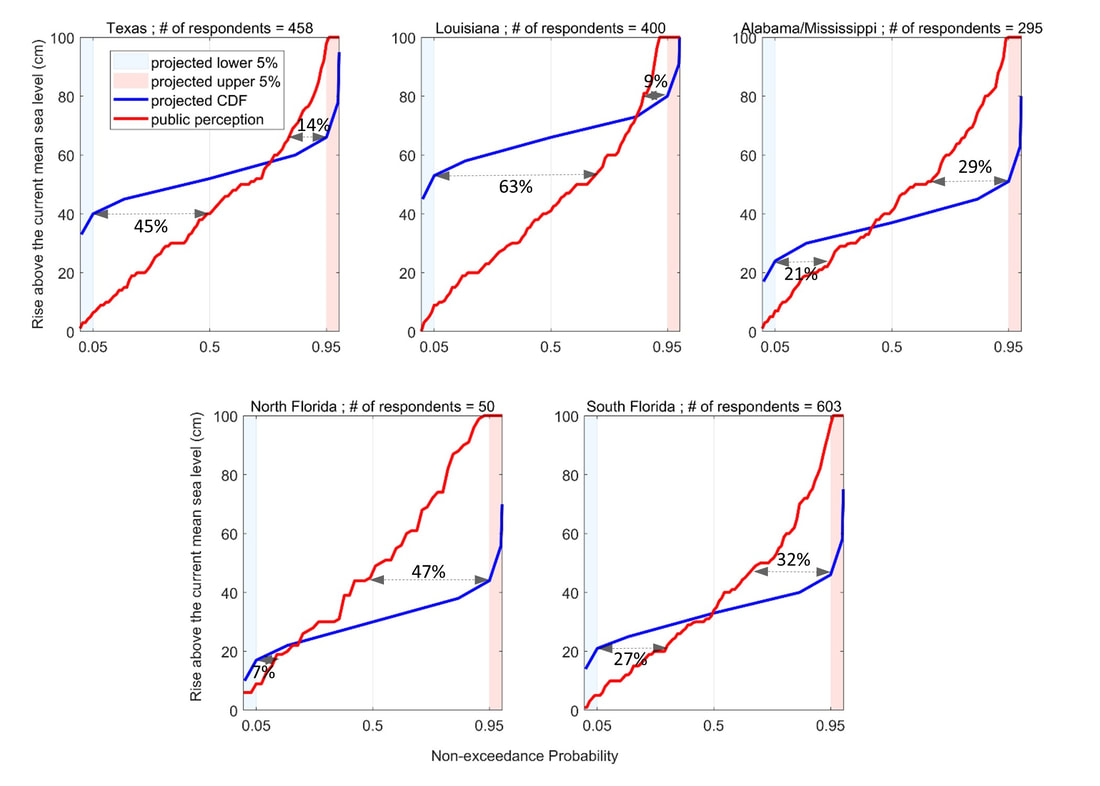 Figure 3. Comparison of public estimation with scientific estimation of SLR at five locations in Texas, Louisiana, Mississippi and Alabama, Florida Panhandle, and Florida Peninsula along the U.S. Gulf Coast. Percentages assigned at lower level and upper level in each figures represent percentages of respondents who estimated future SLR to be lower than the 5th and higher than the 95th scientific estimates, respectively (Source: Shao et al. in press). In a new paper that has been published in Social Science & Medicine (Impact Factor: 4.634), we studied the factors on risk perceptions of COVID-19. Below please find the abstract: Rationale COVID-19 poses an unprecedented level of risks to the public health and well-being in the United States. This pandemic has led to cascading effects such as rapidly rising unemployment rate, deteriorating mental health, and disturbed stock market among others. This disease presents an opportunity for social scientists to conduct a timely study of American public perceptions of risks associated with COVID-19. Objective Due to a great amount of uncertainties surrounding this disease, the public has to rely upon authorities for information and guidance. In this study, we aim to answer this overarching question: how does confidence in political leaders shape American public risk perceptions of COVID-19? Method Based on a nationally representative data conducted in March 2020, we use latent mean comparison analysis and Structural Equation Modelling to make several findings. Results First, confidence in political leaders can reduce risk perceptions of this disease. Second, conservatives show lower risk perceptions than liberals and moderates. Third, confidence in political leaders has mediating effects among conservatives and white Americans, where conservatives and white Americans who have more confidence in political leaders show lower risk perceptions of COVID-19 than other conservatives and white Americans who have less confidence. Conclusion These results highlight the enormous challenges facing policy makers who intend to design and implement national public health policies in this polarized environment.  Figure 1. Structural Equation Modelling Diagram (Shao and Hao, 2020 b) 12/29/2019 2 Comments A new paper in Scientific Reports In a new paper, we assessed the socio-economic vulnerability to flash floods across the contiguous U.S. This paper has been published in Scientific Reports (a Nature journal). For more information, below please find the abstract: "Flash flood is among the most catastrophic natural hazards which causes disruption in the environment and societies. Flash flood is mainly initiated by intense rainfall, and due to its rapid onset (within six hours of rainfall), taking action for effective response is challenging. Building resilience to flash floods require understanding of the socio-economic characteristics of the societies and their vulnerability to these extreme events. This study provides a comprehensive assessment of socio-economic vulnerability to flash floods and investigates the main characteristics of flash flood hazard, i.e. frequency, duration, severity, and magnitude. A socio-economic vulnerability index is developed at the county level across the Contiguous United States (CONUS). For this purpose, an ensemble of social and economic variables from the US Census and the Bureau of Economic Analysis were analyzed. Then, the coincidence of socio-economic vulnerability and flash flood hazard were investigated to identify the critical and non-critical regions. Results show that the southwest U.S. experienced severe flash flooding with high magnitude, whereas the Northern Great Plains experience lower severity and frequency. Critical counties (high-vulnerable-hotspot) are mostly located in the southern and southwestern parts of the U.S. The majority of counties in the Northern Great Plains indicate a non-critical status." 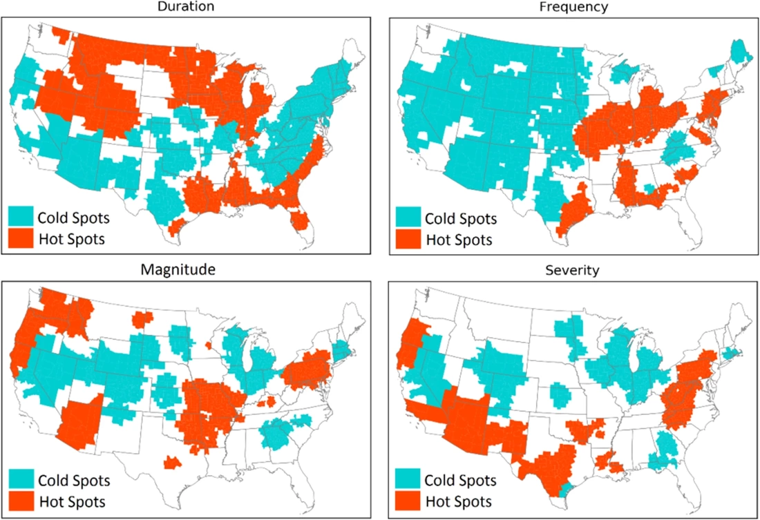 Figure 7. Flash flood hazard characteristics converted from gauge station to the county-scale (Khajehei et al. 2020) 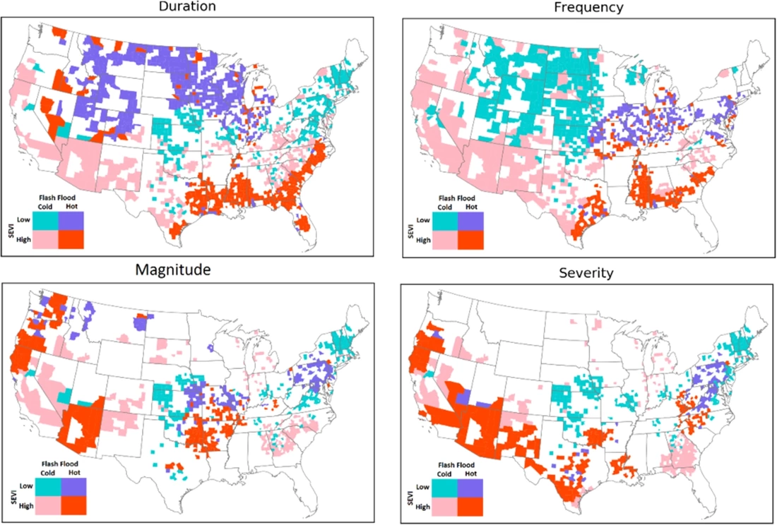 Figure 8. Maps of the counties where flashflood extremes coincide with socio-economic vulnerability extremes (Khajehei et al. 2020) In a new paper, we used Google Trends to reveal the spatiotemporal patterns of US drought awareness. This paper has been published in Palgrave Communications (a Nature journal, now Humanities and Social Sciences Communications). Here is more information about this paper: Article Title: Spatiotemporal Patterns of US Drought Awareness Summary: Drought is a creeping climatological phenomenon with persistent precipitation deficits. The intangible and gradual characteristics of drought cause a lack of social response during the onset. The level of awareness of a local drought increases rapidly through mass media reports and online information searching activities when the drought reaches its peak severity. This high level of local drought awareness drives concerns for water shortage and support for water policy. However, spatiotemporal patterns of national-scale drought awareness have never been studied due to constraints imposed by time-consuming and costly survey data collection and surveys' limited sample sizes. Here, we present the national-scale study to reveal the spatiotemporal patterns of drought awareness over the contiguous United States (CONUS) using Google Trends data and an advanced statistical technique, Principal Component Analysis (PCA). Results show that the first two PC modes can explain 48% (38% for PC1 and 10% for PC2; see Figures below) of the total variance of state-level drought awareness. We find that the PC1 mode relates to a national pattern of drought awareness across the CONUS. The spatiotemporal patterns further imply that residents in the Northeastern US region are the most aware of the emergence of drought, regardless of the geographic location of the occurrence. The results illustrate how search engine queries and social media data can help develop an effective and efficient plan for drought mitigation in the future. The following Figure comes from Kim et al. (2019): 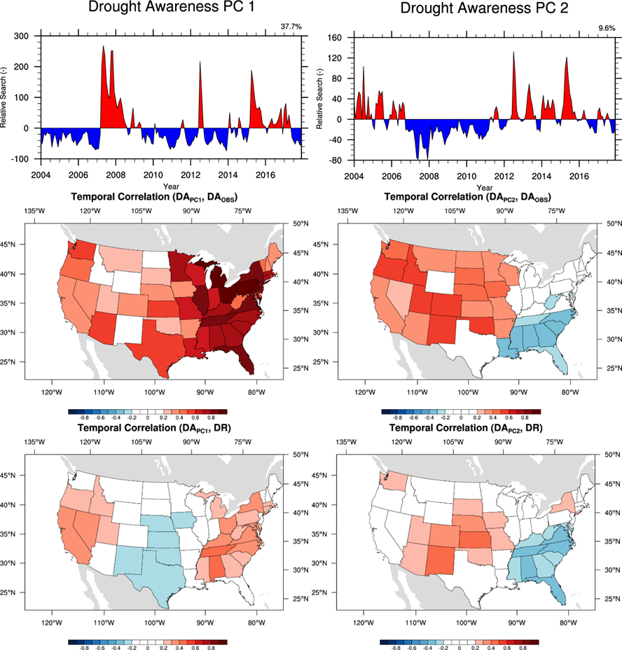 Figure 1: Major principle components of state-level drought awareness and state-level drought risk over the contiguous United States. Temporal correlations of Drought Awareness from the first two major modes with individual state-level drought awareness ((c) and (d), respectively) and individual state-level drought risk ((e) and (f), respectively). White colored states depict the states with insignificant temporal correlation at the 99% confident level. 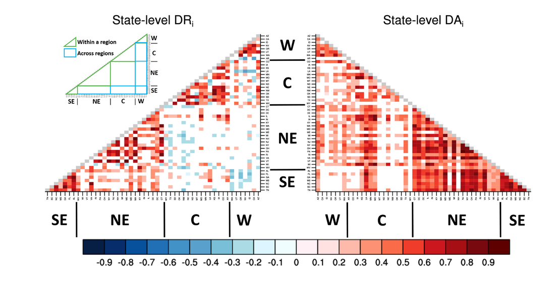 Figure 2: State-level correlation analysis of drought awareness and drought risk. Colors in the grid cells depict temporal correlation coefficients of state-level drought awareness (left triangle) and state-level drought risk (right triangle) of one state with those of the rest 48 states. To assist interpretation, areas that depict interstate relationships within the region (green colored boundaries) and across regions (blue colored boundaries) are shown in the legend box at upper-left corner.
6/28/2019 1 Comment A new paper in Disasters Our new paper was published in Disasters (impact factor: 1.797). Here is the abstract: "It is of significance to assess and depict community vulnerability to floods and hurricanes. Over the past several decades, flooding and hurricanes have affected millions of people and caused massive economic losses. Despite efforts to reduce risks, these natural hazards remain to be a considerable challenge to coastal communities. In this paper, Geographic Information Systems (GIS) methods are used to analyze coastal communities’ vulnerability to hurricanes and flooding along the U.S. Gulf coast, which is prone to these two hazards. Specifically, two types of quantitative indicators are developed: exposure to hurricanes and flooding, based on data from multiple sources such as National Climate Data Center and National Flood Insurance Program among others, and a social vulnerability index, constructed on census data at census tract level. These indices are combined to depict the spatial patterns of overall community vulnerability to flooding and hurricane hazards along the U.S. Gulf Coast. Results of this study can potentially inform disaster management agencies, county governments and municipalities of areas with heightened community vulnerabilities. The demonstration of geographic distribution of community vulnerability can assist decision makers in prioritizing to‐do items and designing policies/plans for more effective allocation of resources. We end this paper by discussing the limitations to the present study and the practical implications of the assessment." The following two figures are from this article (Shao et al. forthcoming). 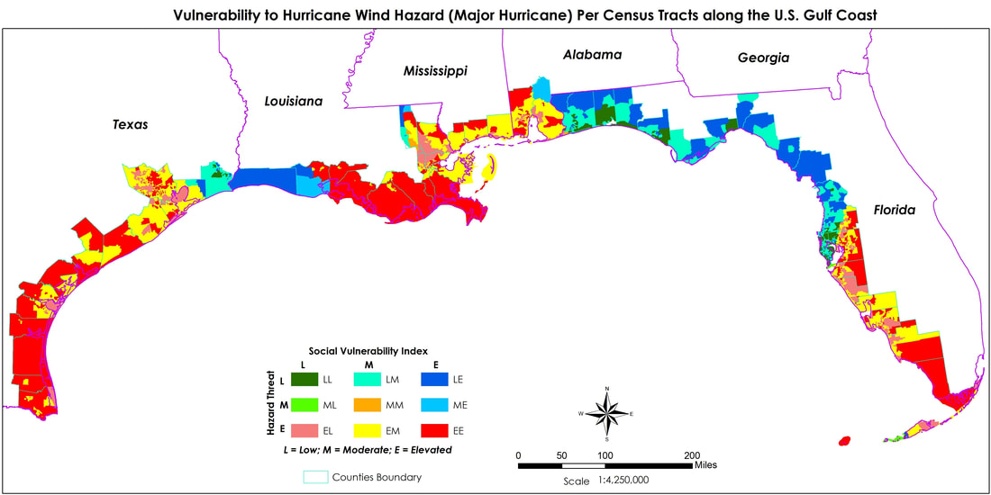 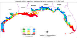
12/21/2018 1 Comment Our new paper on flood perceptions Our new paper on how physical geography influences perceptions of flooding just got published online in the Journal of Hydrology (impact factor: 4.405). Here is the abstract of this paper:
"How does physical history of flood-related hazards affect individuals’ perceptions? The present study represents a unique effort to understand perceptions of flood hazards in light of the geographic background. Situated in Alabama, the United States, the cities of Mobile and Huntsville display two different physical geographic contexts. Despite one being a coastal city (Mobile) and the other being an inland city, both are similarly vulnerable to flooding. We first present results of historical analyses of heavy precipitation in both cities and analysis of storm surge history in the city of Mobile. We then report results of both descriptive statistical and inferential statistical analyses based on a two-city residents’ survey that was conducted in the spring of 2016. We find that residents in both cities are able to connect the particular natural hazard of flooding with their physical environments. Residents in both cities are influenced by their perceptions of precipitation when making assessments of flooding. Despite the fact that Huntsville has not experienced heavy precipitation events as much as Mobile in recent history, residents of Huntsville tend to link heavy rainfall – the most frequent cause of flooding in that city, with flooding. In contrast, residents of Mobile tend to link hurricanes, more particularly hurricane number, with flooding. These results show that people are attuned to their physical environments and take into consideration their personal observations when forming perceptions of natural hazards. More studies need to be conducted to further investigate the dynamics of physical exposure to hazards and risk perceptions in other geographic areas." |

|

 RSS Feed