|
In a new paper that is published in Natural Hazards, we applied multiple algorithms to model flood susceptibility in New Orleans. Please find the abstract below: "Machine learning (ML) models, particularly decision tree (DT)-based algorithms, are being increasingly utilized for flood susceptibility mapping. To evaluate the advantages of DT-based ML models over traditional statistical models on flood susceptibility assessment, a comparative study is needed to systematically compare the performances of DT- based ML models with that of traditional statistical models. New Orleans, which has a long history of flooding and is highly susceptible to flooding, is selected as the test bed. The primary purpose of this study is to compare the performance of multiple DT-based ML models namely DT, Adaptive Boosting (AdaBoost), Gradient Boosting (GdBoost), Extreme Gradient Boosting (XGBoost) and Random Forest (RF) models with a traditional statistical model known as Frequency Ratio (FR) model in New Orleans. This study also aims to identify the main drivers contributing to flooding in New Orleans using the best performing model. Based on the most recent Hurricane Ida-induced flood inventory map and nine crucial flood conditioning factors, the models’ accuracies are tested and compared using multiple evaluation metrics. The findings of this study indicate that all DT-based ML models perform better compared to FR. The RF model emerges as the best model (AUC = 0.85) among all DT-based ML models in every evaluation metrics. This study then adopts the RF model to simulate flood susceptibility map (FSM) of New Orleans and compares it with the prediction of FR model. The RF model also demonstrates that low elevation and higher precipitation are the main factors responsible for flooding in New Orleans. Therefore, this comparative approach offers a significant understanding about the advantages of advanced ML models over traditional statistical models in local flood susceptibility assessment." 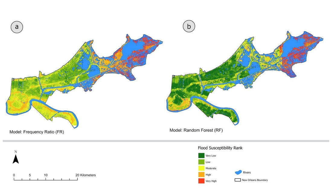 The flood susceptibility maps of New Orleans city. a FSM produced by FR model. b FSM produced by RF model
0 Comments
8/31/2022 2 Comments Our new paper on the socio-geographic patterns of rescue requests during Hurricane Harvey has been published in Findings Our paper on the socio-geographic patterns of rescue requests during Hurricane Harvey has been published in Findings. Below is the abstract: "We analyze a public dataset of rescue requests for the Houston Metropolitan Area during Hurricane Harvey (2017) from the Red Cross. This dataset contains information including the location, gender, and emergency description in each requester’s report. We reveal the spatial distribution of the rescue requests and its relationship with indicators of the social, physical, and built environment. We show that the rescue request rates are significantly higher in regions with higher percentages of children, male population, population in poverty, or people with limited English, in addition to regions with higher inundation rate or worse traffic condition during Hurricane Harvey. The rescue request rate is found to be statistically uncorrelated with the percentage of flood hazard zone designated by the Federal Emergency Management Agency (FEMA)." 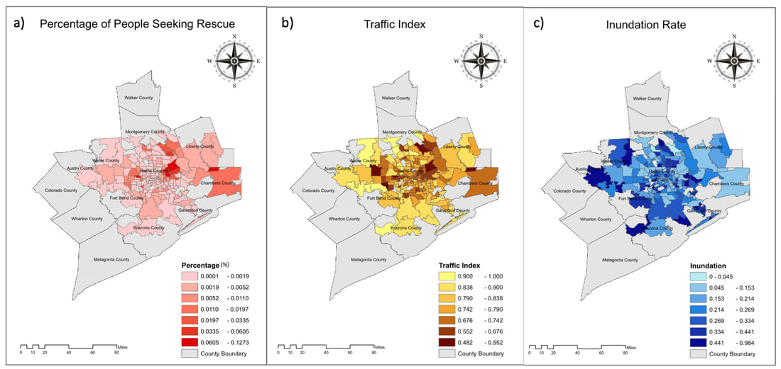 Figure 1.Spatial Distribution of Event-related Variables in Each Zip Code. a). Percentage of people who sought rescues during Harvey, b). Traffic index during Harvey, c). Inundation index during Harvey. 8/2/2022 0 Comments Open PhD Position – coastal community resilience, risk perceptions, community engagement, Nature Based Solution The Environmental Decision Making Lab at the Department of Geography of the University of Alabama seeks a geography PhD student to focus on coastal community resilience, risk perceptions, community engagement under the theme of Nature Based Solution (NBS). The broader research team is focused on developing actionable design guidance for NBS (i.e., wetland restoration) along the US Gulf Coast. Our highly interdisciplinary group includes social scientists, wetland ecologists, water resource engineers, and government agency partners. Our goal is to develop guidance for wetland restoration activities optimized to reduce flooding and increase coastal community resilience. To accomplish this goal, we will employ a combination of community engagement, wetland plant community characterization, and state-of-the-art hydrologic and hydraulic modeling.
The successful candidate will be expected to start in spring, 2023. The candidate will work closely with social scientists, wetland ecologists, and water resource engineers, and our government partners to develop, assess, and communicate NBS design alternatives by engaging stakeholders in a knowledge co-production fashion. The candidate will be expected to work with the team to develop a plan for stakeholder engagement meetings, organize and facilitate stakeholder engagement activities, collect the data from the meetings, analyze the data, and report findings in peer-reviewed manuscripts. Through this work, the candidate will also be expected to develop hypothesis driven research based on their interests. The ideal candidate will have MS degrees in a relevant field (i.e., geography, urban and regional planning, environmental sociology, ecology, environmental science, or closely related field). The candidate should be excited about working on an interdisciplinary team; interacting with community partners, and conducting both basic and applied research. Further, experience with statistical analysis and programs (e.g., R, Stata, SPSS) and geographic information systems (e.g., ArcGIS, QGIS) are required. Experience with textual analysis programs (e.g., NVivo) is preferred but not required. Additionally, experience with scripting languages (e.g., R, Python, or Matlab) are preferred but not required. For more information, please contact Dr. Wanyun Shao (wshao1@ua.edu) Our new paper, entitled "Understanding the Influence of Political Orientation, Social Network, and Economic Recovery on COVID-19 Vaccine Uptake among Americans" has been published online in Vaccine (Impact factor: 3.641). Below please find the abstract:
"The COVID-19 pandemic poses unprecedented risks to the well-being of Americans. To control the pandemic, a sufficient proportion of the population needs to be vaccinated promptly. Despite the proven efficacy and widespread availability, vaccine distribution and administration rates remain low. Thus, it is important to understand the public behavior of COVID-19 vaccination. This study aims to identify determinants at multiple levels that promote or inhibit one’s vaccine uptake. We combine individual-level data from a national survey conducted in the summer of 2021 with corresponding state-level indicators. Findings of multilevel logistic regression show that political orientation, social network, and economic recovery altogether have significant influence. We articulate that individual decisions to take the vaccine are a function of their personal characteristics and are also rooted in their home state’s political, public health, and economic contexts. These findings contribute to the literature and have policy implications. Knowledge of the profiles among people who take/refuse the vaccine provides essential information to leverage certain factors and maximize vaccine uptake to mitigate the pandemic’s devastating impact." Our analysis article reflecting on the COVID-19 year was just published on the Conversation:
"Even though Americans shared the experience of living through a global pandemic, their individual attitudes towards it differed and evolved – sometimes dramatically... Overall, our research shows the combination of timely information with trusting, well-connected communities, is most likely to result in collective risk mitigation behavior. Perhaps these insights can help the U.S. prepare better for the next pandemic." 2/15/2021 0 Comments Our new paper in Health and Place Our new paper entitled "Understanding the influence of contextual factors and individual social capital on American public mask wearing in response to COVID-19" has been published in Health and Place (Impact Factor: 4.078) . Below please find the abstract: "The COVID–19 pandemic poses unprecedented risks to the health and well-being of the entire population in the U.S. To control the pandemic, it is imperative for individuals to take precautionary behaviors (e.g., wearing a mask, keeping social distance, washing hands frequently, etc.). The factors that influence individual behavioral response thus warrants a close examination. Using survey data for respondents from 10 states merged with state-level data, our study represents a pioneering effort to reveal contextual and individual social capital factors that explain public mask wearing in response to COVID–19. Findings of logistic multilevel regression show that the COVID–19 death rate and political control of government at the state level along with one’s social capital at the individual level altogether influence whether people decide to wear face masks. These findings contribute to the rapidly growing literature and have policy implications for mitigating the pandemic’s devastating impact on the American public." 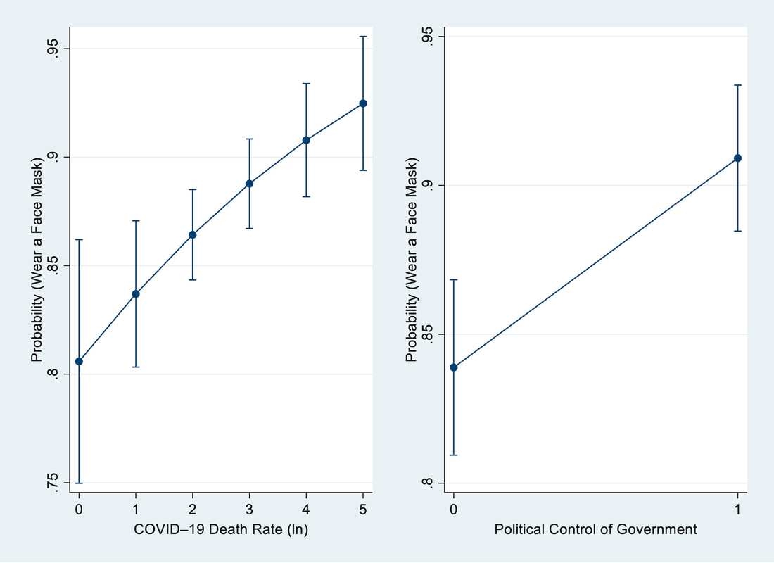 Fig. 2. Estimated Odds of Wearing a Face Mask predicted by State-Level COVID–19 Death Rate and Political Control of Government (Hao et al. 2021) 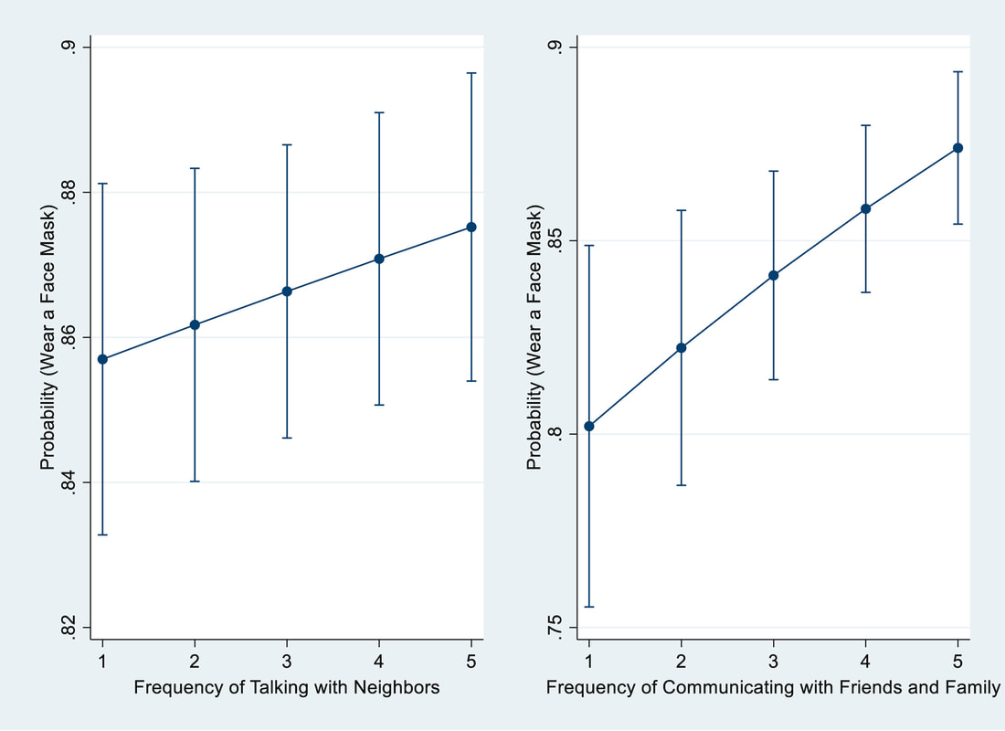 Fig. 3. Estimated Odds of Wearing a Face Mask predicted by Social Capital Indicators (Hao et al. 2021). 10/1/2020 2 Comments A Ph.D opportunity My research group Environmental Decision Making at the Department of Geography at the University of Alabama is accepting applications for a Ph.D student with research assistantship, in social dimension of hazards in general and flood hazards in particular. The assistantship provides a stipend plus tuition remission.
The successful applicant will work with me and two research groups at the Department of Civil, Construction, and Environmental Engineering and will be involved in projects focused on human dimension of flood hazards. Qualified candidates should have a Master’s degree in Geography, Environmental Studies/Sciences, Planning or a related discipline. Candidates should have a strong interest in the intersection of social and physical dimensions of hazards and be eager to work in an interdisciplinary environment. Experience in quantitative data analysis, survey design, geographic information systems (GIS) are desired. Strong oral and written communication skills are required. For more information about this assistantship, please contact me at wshao1@ua.edu well in advance of February 15, 2021 (the application deadline). Please include a copy of your CV, unofficial academic transcripts, and a brief personal statement that highlights skills relevant to the position. For more information about the department, please see https://geography.ua.edu/. The website of my lab Environmental Decision Making at UA is up and running. Please check it out.
We encourage inquires from prospective Master of Science or Ph.D students with research interests in environmental decision making within a geographic context. In particular, we seek students with training in statistics, data analysis, quantitative methods, and Geographic Information System (GIS). Students' specific research interests can include: 1. environmental risk perceptions 2. individual adaptive behavior/intention 3. community vulnerability and resilience 4. environmental planning/policy 5. environmental hazards and public health If you are interested in joining us, please send your inquiry along with your CV., unofficial transcripts, test scores to Dr. Wanyun Shao at wshao1@ua.edu. I have joined the International Editorial Board of Palgrave Communications (a Nature journal). I am an associate editor in the subject area of Geography and Demography.
Palgrave Communications is a fully open-access, online journal publishing peer-reviewed research across the full spectrum of the humanities and social sciences. Palgrave Communications welcomes the submission of in-depth interdisciplinary studies. In a new paper, we used Google Trends to reveal the spatiotemporal patterns of US drought awareness. This paper has been published in Palgrave Communications (a Nature journal, now Humanities and Social Sciences Communications). Here is more information about this paper: Article Title: Spatiotemporal Patterns of US Drought Awareness Summary: Drought is a creeping climatological phenomenon with persistent precipitation deficits. The intangible and gradual characteristics of drought cause a lack of social response during the onset. The level of awareness of a local drought increases rapidly through mass media reports and online information searching activities when the drought reaches its peak severity. This high level of local drought awareness drives concerns for water shortage and support for water policy. However, spatiotemporal patterns of national-scale drought awareness have never been studied due to constraints imposed by time-consuming and costly survey data collection and surveys' limited sample sizes. Here, we present the national-scale study to reveal the spatiotemporal patterns of drought awareness over the contiguous United States (CONUS) using Google Trends data and an advanced statistical technique, Principal Component Analysis (PCA). Results show that the first two PC modes can explain 48% (38% for PC1 and 10% for PC2; see Figures below) of the total variance of state-level drought awareness. We find that the PC1 mode relates to a national pattern of drought awareness across the CONUS. The spatiotemporal patterns further imply that residents in the Northeastern US region are the most aware of the emergence of drought, regardless of the geographic location of the occurrence. The results illustrate how search engine queries and social media data can help develop an effective and efficient plan for drought mitigation in the future. The following Figure comes from Kim et al. (2019): 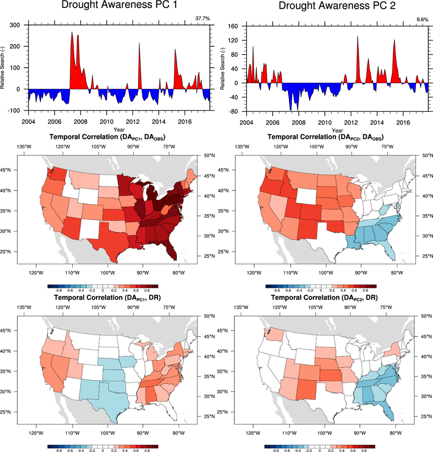 Figure 1: Major principle components of state-level drought awareness and state-level drought risk over the contiguous United States. Temporal correlations of Drought Awareness from the first two major modes with individual state-level drought awareness ((c) and (d), respectively) and individual state-level drought risk ((e) and (f), respectively). White colored states depict the states with insignificant temporal correlation at the 99% confident level. 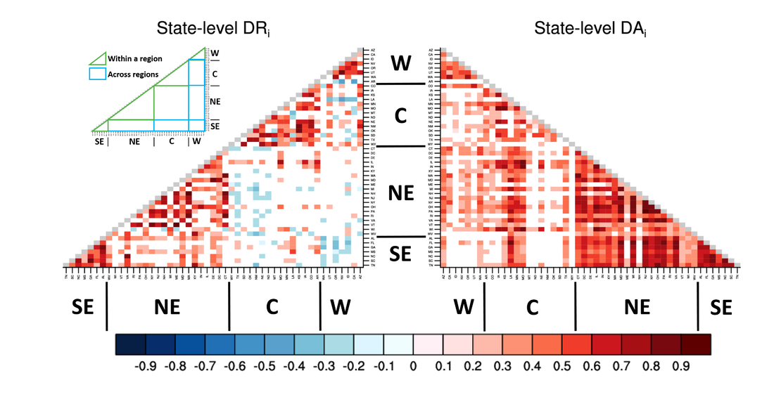 Figure 2: State-level correlation analysis of drought awareness and drought risk. Colors in the grid cells depict temporal correlation coefficients of state-level drought awareness (left triangle) and state-level drought risk (right triangle) of one state with those of the rest 48 states. To assist interpretation, areas that depict interstate relationships within the region (green colored boundaries) and across regions (blue colored boundaries) are shown in the legend box at upper-left corner.
|

|

 RSS Feed