|
6/28/2019 1 Comment A new paper in Disasters Our new paper was published in Disasters (impact factor: 1.797). Here is the abstract: "It is of significance to assess and depict community vulnerability to floods and hurricanes. Over the past several decades, flooding and hurricanes have affected millions of people and caused massive economic losses. Despite efforts to reduce risks, these natural hazards remain to be a considerable challenge to coastal communities. In this paper, Geographic Information Systems (GIS) methods are used to analyze coastal communities’ vulnerability to hurricanes and flooding along the U.S. Gulf coast, which is prone to these two hazards. Specifically, two types of quantitative indicators are developed: exposure to hurricanes and flooding, based on data from multiple sources such as National Climate Data Center and National Flood Insurance Program among others, and a social vulnerability index, constructed on census data at census tract level. These indices are combined to depict the spatial patterns of overall community vulnerability to flooding and hurricane hazards along the U.S. Gulf Coast. Results of this study can potentially inform disaster management agencies, county governments and municipalities of areas with heightened community vulnerabilities. The demonstration of geographic distribution of community vulnerability can assist decision makers in prioritizing to‐do items and designing policies/plans for more effective allocation of resources. We end this paper by discussing the limitations to the present study and the practical implications of the assessment." The following two figures are from this article (Shao et al. forthcoming). 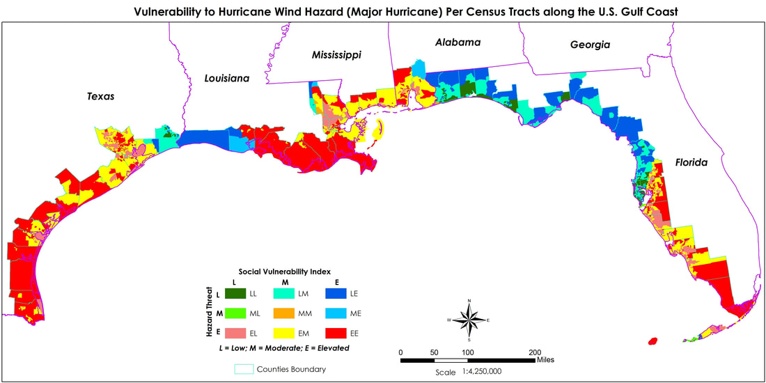 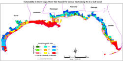
1 Comment
Our paper on public support for flood mitigation was just published on Environmental Research Letters (impact factor: 6.192). Here is the abstract: "What is the decision-making mechanism people rely upon to mitigate flood risk? Applying Bayesian Network modelling to a comprehensive survey dataset for the U.S. Gulf Coast, we find that the overall support for flood mitigation can be inferred from flood insurance purchase behavior (i.e., without insurance vs. with insurance purchased mandatorily, voluntarily, or both). Therefore, we propose a theoretical decision-making mechanism composed of two dimensions including informed flood risk and sense of insecurity. The informed flood risk is the primary determinant on one's overall support for flood mitigation. Risk mitigation decisions are largely contingent on the level of risk that is effectively conveyed to individuals. Additionally, sense of insecurity plays a moderate role in determining individuals' overall support for flood mitigation. The sense of insecurity can move people toward overall support for mitigation, but the effect is not as large as the informed risk. Results of this study have fundamental policy implications. The flood risk informed by Federal Emergency Management Agency's flood maps not only provides the compulsory basis for flood insurance purchase but also determines individuals' overall support for flood mitigation. Flood map inaccuracy can immensely mislead individuals' overall risk mitigation decision. Meanwhile, this flood risk mitigation decision-making mechanism inferred from a survey data in the U.S. Gulf Coast needs to be tested and validated elsewhere." In this paper, we proposed a flood mitigation decision-making mechanism (please see below). One implication of this study is that "the importance of risk information in overall flood mitigation decisions. Although the flood premiums do not reflect real risks due to discounts, flood hazard zones have effectively conveyed the risk to homeowners. Risk signals can thus be delivered to homeowners through various means." 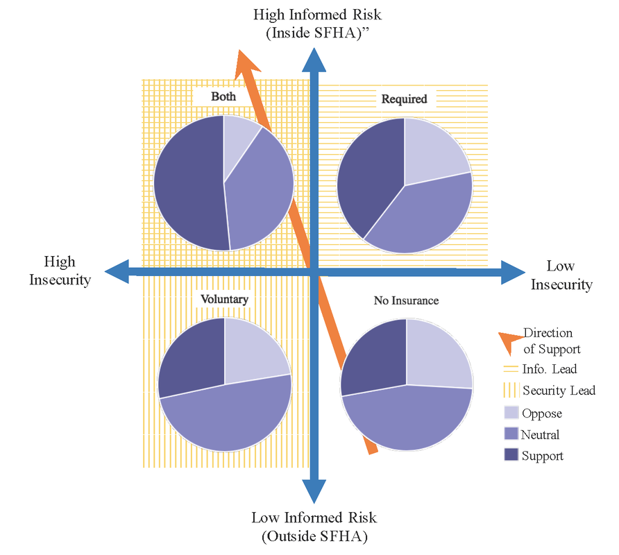 12/21/2018 1 Comment Our new paper on flood perceptions Our new paper on how physical geography influences perceptions of flooding just got published online in the Journal of Hydrology (impact factor: 4.405). Here is the abstract of this paper:
"How does physical history of flood-related hazards affect individuals’ perceptions? The present study represents a unique effort to understand perceptions of flood hazards in light of the geographic background. Situated in Alabama, the United States, the cities of Mobile and Huntsville display two different physical geographic contexts. Despite one being a coastal city (Mobile) and the other being an inland city, both are similarly vulnerable to flooding. We first present results of historical analyses of heavy precipitation in both cities and analysis of storm surge history in the city of Mobile. We then report results of both descriptive statistical and inferential statistical analyses based on a two-city residents’ survey that was conducted in the spring of 2016. We find that residents in both cities are able to connect the particular natural hazard of flooding with their physical environments. Residents in both cities are influenced by their perceptions of precipitation when making assessments of flooding. Despite the fact that Huntsville has not experienced heavy precipitation events as much as Mobile in recent history, residents of Huntsville tend to link heavy rainfall – the most frequent cause of flooding in that city, with flooding. In contrast, residents of Mobile tend to link hurricanes, more particularly hurricane number, with flooding. These results show that people are attuned to their physical environments and take into consideration their personal observations when forming perceptions of natural hazards. More studies need to be conducted to further investigate the dynamics of physical exposure to hazards and risk perceptions in other geographic areas." A year after Hurricane Harvey, the decisions to rebuild can affect the future. I just published an analysis article on the Conversation. Here is the last paragraph:
"My recent research shows that even with their flaws, FEMA flood maps influence decisions to purchase flood insurance and overall support for flood mitigation. Policy makers need to seriously consider how to accurately communicate increasing flood risks to the public. Reverting to old flood maps and granting variances to promote development is a recipe for more disasters down the road." Hat tip to Emily Powell at the National Wildlife Federation, who brought this situation to my attention. 6/21/2018 0 Comments Visit at Princeton I enjoyed the visit at the Department of Civil and Environmental Engineering at Princeton University. I have had great discussions with Professor Lin and her Hurricane Hazards and Risk Analysis Research Group.  Princeton Campus 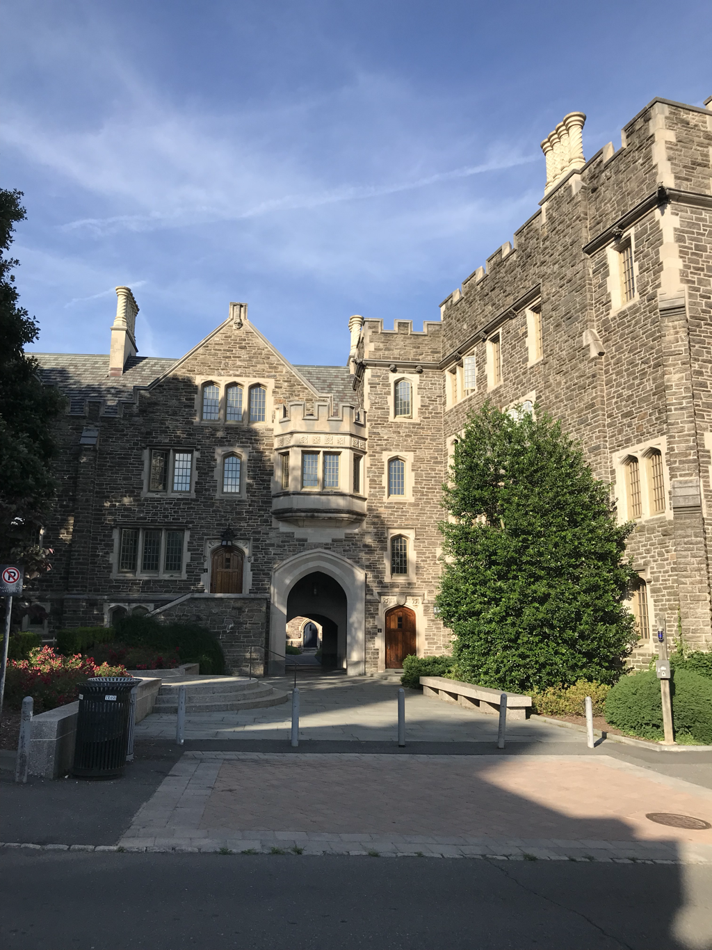 Princeton Campus  Princeton Campus  I am sitting on a chair on Princeton Campus  I am standing in front of the student center I am honored to be invited to give a seminar talk, entitled "Understanding Human Judgement on Environmental Risks and Hazards in a Geographic Context," at the Department of Civil and Environmental Engineering at Princeton University on June 21.
The abstract of the talk is as follows: "The coupling effects of changing climate and rising concentration of population and assets in the coastal regions have increased the threat of potential damages. There is an urgent need for coastal communities to prepare well for future hazards through mitigation and adaptation measures. A growing number of empirical studies have found that peoples’ motivation of voluntary risk mitigation and adaptation is low unless actual risk can be perceived. Risk perception is thus the precondition for adaptive behavior. It is of both intellectual and practical interests to study what affects individuals’/communities’ risk perceptions. In this talk, I will present four of my previous studies. The first three studies are focused on the individual level and the fourth on the aggregate level. I will start with understanding how local weather and climate affect American public risk perceptions of climate change. I will then discuss how the spatial context represented by past flooding events and estimated flooding risks influence costal residents’ voluntary flood insurance purchase decisions and their support for flood adaptation policies. As many policies are designed and implemented at an aggregate level (i.e., state, county, city), it is necessary to examine aggregate-level risk perceptions. In the fourth study, I will focus on how the contextual hurricane risks in conjunction with community resilience shape county-level perceptions of hurricane-related risks. I will end with a research agenda linking communities’ perception with contextual risks and community resilience. I contend that the cognitive dimension including both risk perceptions and perceived adaptive capacity is not represented in any of the existing community resilience indexes, and therefore needs to be measured, quantified, and incorporated into a more comprehensive index." Hurricane Harvey dumped record-breaking rain in Houston in 2017. Now, a new study shows that this extreme amounts of rainfalls actually resulted from unprecedented ocean heat content. This study presents some evidence to support the link between global temperature rise with increasing hurricane intensity.
I presented my research on understanding human judgments on environmental risks and hazards in a geographic context at the American Association of Geographers annual conference in New Orleans, LA. I also presented our study on environmental hazards and mental health among Gulf Coastal counties in this meeting. 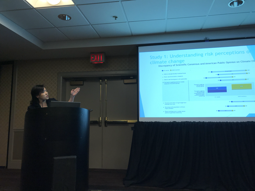 The figure in the slide is from the Pew Research Center for the People and the Press Our new paper on aggregate perceptions of hurricane risks has been published on the Annals of American Association of Geographers.
I presented our study on community resilience and county-level perceptions of hurricane risks along the US Gulf Coast at the 2017 Society for Risk Analysis annual conference in Arlington, VA. 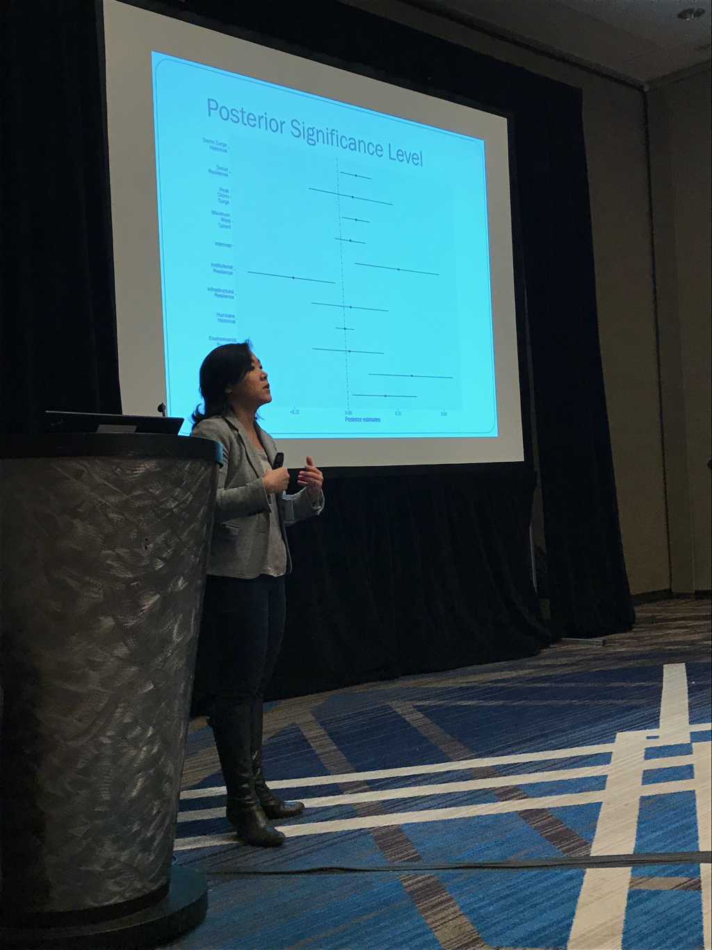 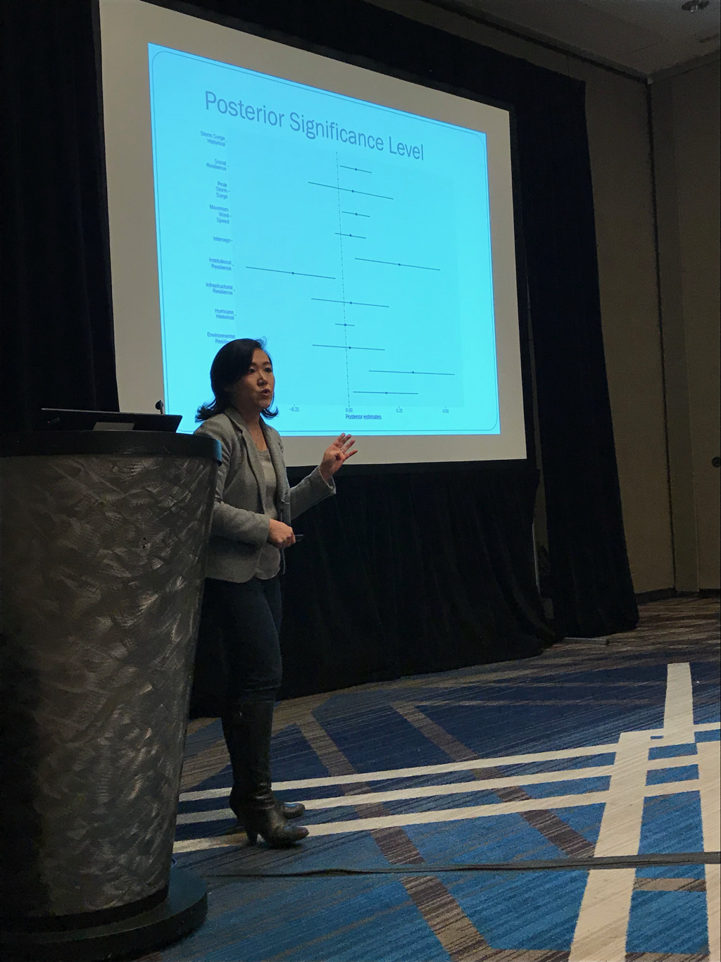 |

|

 RSS Feed