|
In a new paper that is published in Natural Hazards, we applied multiple algorithms to model flood susceptibility in New Orleans. Please find the abstract below: "Machine learning (ML) models, particularly decision tree (DT)-based algorithms, are being increasingly utilized for flood susceptibility mapping. To evaluate the advantages of DT-based ML models over traditional statistical models on flood susceptibility assessment, a comparative study is needed to systematically compare the performances of DT- based ML models with that of traditional statistical models. New Orleans, which has a long history of flooding and is highly susceptible to flooding, is selected as the test bed. The primary purpose of this study is to compare the performance of multiple DT-based ML models namely DT, Adaptive Boosting (AdaBoost), Gradient Boosting (GdBoost), Extreme Gradient Boosting (XGBoost) and Random Forest (RF) models with a traditional statistical model known as Frequency Ratio (FR) model in New Orleans. This study also aims to identify the main drivers contributing to flooding in New Orleans using the best performing model. Based on the most recent Hurricane Ida-induced flood inventory map and nine crucial flood conditioning factors, the models’ accuracies are tested and compared using multiple evaluation metrics. The findings of this study indicate that all DT-based ML models perform better compared to FR. The RF model emerges as the best model (AUC = 0.85) among all DT-based ML models in every evaluation metrics. This study then adopts the RF model to simulate flood susceptibility map (FSM) of New Orleans and compares it with the prediction of FR model. The RF model also demonstrates that low elevation and higher precipitation are the main factors responsible for flooding in New Orleans. Therefore, this comparative approach offers a significant understanding about the advantages of advanced ML models over traditional statistical models in local flood susceptibility assessment." 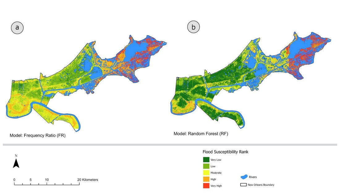 The flood susceptibility maps of New Orleans city. a FSM produced by FR model. b FSM produced by RF model
0 Comments
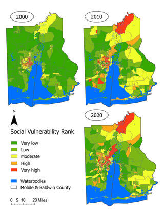
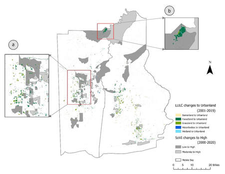
11/17/2023 2 Comments Our new paper on changing community vulnerability in the U.S. Mobile Bay from 2000 - 2020Our new paper is published in the journal Applied Spatial Analysis and Policy. Below is the abstract: "The coastal community is confronted with heightened risks posed by climate change. Mobile Bay in the United States is a large estuarine system along the Gulf of Mexico (GOM) coast, providing critical ecosystem services for the nation. This region is however subject to increased urbanization and uncertain impacts of climate change. To ensure sustainability of this important ecosystem, it is imperative to examine the changing spatial patterns of community vulnerability to environmental changes in this region. Using data from the U.S. Census of multiple years, we investigate the changing spatial patterns of social vulnerability at the census block group level in Mobile Bay consisting of Mobile County and Baldwin County over the past 20 years (2000 – 2020). Additionally, we utilize hotspot and cluster analyses to formalize the observations of the spatiotemporal changes. Further, we examine how land use and land cover (LULC) changes co-occur with social vulnerability changes across Mobile Bay. We identify several hotspots where land cover has been converted to urban land and social vulnerability has increased. The investigation of the spatial patterns over a relatively long period helps to deepen the insight into the dynamic spatiotemporal changes of social and environmental vulnerability. This insight can better inform future plans to cope with climate change and ensure sustainability. Specifically, hotspots that have undergone urbanization and increased social vulnerability demand special attention from policy makers for future risk mitigation and disaster planning."
5/30/2023 0 Comments Our new paper was published in the International Journal of Disaster Risk ReductionOur new paper identifying effective hurricane risk communication tools was published in the International Journal of Disaster Risk Reduction. Below please find the abstract:
"Coastal regions such as the U.S. Atlantic and Gulf Coasts are highly vulnerable to extreme coastal hazards such as tropical cyclones and major hurricanes. The effects of these hazards pose a threat now and are expected to increase in the future, which highlights the need for coastal communities to receive and understand information regarding risks involved with these hazards. Through this study, we identify points of improvement in the tools used to communicate the short and long-term risk associated with hurricane hazards through three surveys in Mobile, AL, Savannah, GA, and Houston TX. These surveys identify public response to hurricane descriptions, Cone of Uncertainty graphics, and long-term trend graphics. Analysis of trends in responses to these communication tools identifies relationships between risk perceptions and existing factors in each study location. Further, public response to these tools is identified and analyzed using structural equation models for each location with a “response” latent variable containing information from endogenous variables in the survey. Response was measured as action intent, concern for the scenario, reported evacuation likelihood, and interpretation of long-term trends. We identify points of improvement for all three communication tools to aid in public comprehension of the information provided as well as to increase response to hurricane hazards by more effectively communicating risk information. These would help to improve comprehension and increase different responses to tropical storm and hurricane damage from high winds and storm surge with the intent to improve resident response to hazards along the U.S. Atlantic and Gulf Coasts." 8/31/2022 2 Comments Our new paper on the socio-geographic patterns of rescue requests during Hurricane Harvey has been published in Findings Our paper on the socio-geographic patterns of rescue requests during Hurricane Harvey has been published in Findings. Below is the abstract: "We analyze a public dataset of rescue requests for the Houston Metropolitan Area during Hurricane Harvey (2017) from the Red Cross. This dataset contains information including the location, gender, and emergency description in each requester’s report. We reveal the spatial distribution of the rescue requests and its relationship with indicators of the social, physical, and built environment. We show that the rescue request rates are significantly higher in regions with higher percentages of children, male population, population in poverty, or people with limited English, in addition to regions with higher inundation rate or worse traffic condition during Hurricane Harvey. The rescue request rate is found to be statistically uncorrelated with the percentage of flood hazard zone designated by the Federal Emergency Management Agency (FEMA)." 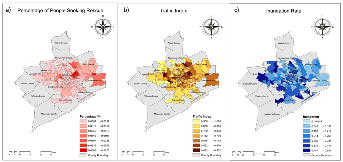 Figure 1.Spatial Distribution of Event-related Variables in Each Zip Code. a). Percentage of people who sought rescues during Harvey, b). Traffic index during Harvey, c). Inundation index during Harvey. 8/2/2022 0 Comments Open PhD Position – coastal community resilience, risk perceptions, community engagement, Nature Based Solution The Environmental Decision Making Lab at the Department of Geography of the University of Alabama seeks a geography PhD student to focus on coastal community resilience, risk perceptions, community engagement under the theme of Nature Based Solution (NBS). The broader research team is focused on developing actionable design guidance for NBS (i.e., wetland restoration) along the US Gulf Coast. Our highly interdisciplinary group includes social scientists, wetland ecologists, water resource engineers, and government agency partners. Our goal is to develop guidance for wetland restoration activities optimized to reduce flooding and increase coastal community resilience. To accomplish this goal, we will employ a combination of community engagement, wetland plant community characterization, and state-of-the-art hydrologic and hydraulic modeling.
The successful candidate will be expected to start in spring, 2023. The candidate will work closely with social scientists, wetland ecologists, and water resource engineers, and our government partners to develop, assess, and communicate NBS design alternatives by engaging stakeholders in a knowledge co-production fashion. The candidate will be expected to work with the team to develop a plan for stakeholder engagement meetings, organize and facilitate stakeholder engagement activities, collect the data from the meetings, analyze the data, and report findings in peer-reviewed manuscripts. Through this work, the candidate will also be expected to develop hypothesis driven research based on their interests. The ideal candidate will have MS degrees in a relevant field (i.e., geography, urban and regional planning, environmental sociology, ecology, environmental science, or closely related field). The candidate should be excited about working on an interdisciplinary team; interacting with community partners, and conducting both basic and applied research. Further, experience with statistical analysis and programs (e.g., R, Stata, SPSS) and geographic information systems (e.g., ArcGIS, QGIS) are required. Experience with textual analysis programs (e.g., NVivo) is preferred but not required. Additionally, experience with scripting languages (e.g., R, Python, or Matlab) are preferred but not required. For more information, please contact Dr. Wanyun Shao (wshao1@ua.edu) 3/31/2022 0 Comments Our new paper has been published in the International Journal of Disaster Risk Reduction Our paper has been published in the International Journal of Disaster Risk Reduction (Impact factor: 4.32). Below please find the abstract: "Climate change has posed serious risks to coastal cities around the world. Effective urban disaster management calls for the coordination between the local government and residents. We propose a comprehensive framework to study urban disaster resilience under climate change with New Orleans of Louisiana in the U.S. as the study area. Municipal hazard mitigation must be sufficient to mitigate these hazards. Residents’ risk perceptions are a vital component of social vulnerability and can shape public decisions to increase disaster resiliency. Because climate change is expected to intensify, it becomes important to ensure that residents’ risk perceptions are considered when developing municipal plans to maximize regional resiliency. This research aims to identify a gap in the hazard mitigation process that can be closed to better prepare the community to manage coastal hazards. To achieve this, an online survey is distributed in the New Orleans metropolitan area to determine residents’ risk perceptions and expectations of the local government’s action. Policy analysis is conducted to identify the priorities held by municipal planners in these issues. Although there is no gap in the perception of risk and municipal mitigation of current coastal hazards, there is a gap between the municipal approach to climate change mitigation and the concern and expectation of actions the residents hold regarding the future effects of climate change. The approach to climate change should be reconsidered on a municipal level and new small-scale personal incentives should be promoted to maximize resiliency toward coastal hazards in the future." 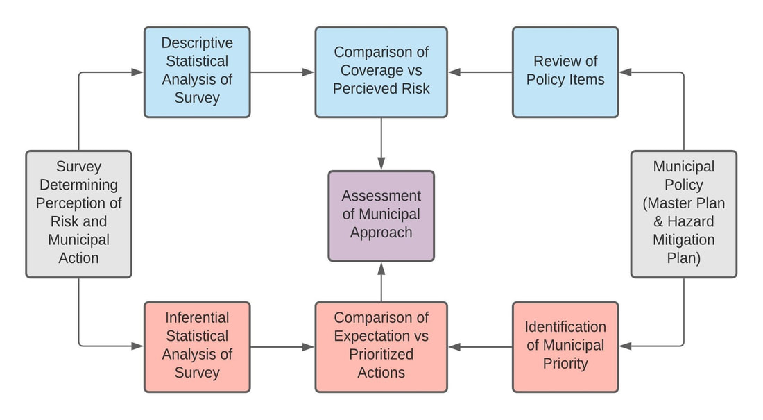 Fig. 2 Framework of Convergent Research on Urban Disaster Resilience Our paper on community vulnerability to floods and hurricanes in the Gulf Coast has been recognized as the most cited paper in the journal Disasters.  Our new paper is published online in Sustainable Cities and Society (impact factor: 7.587). Below please find the abstract: "The use of social media platforms such as Twitter significantly increases during natural hazards. With the emergence of several social media platforms over the past decade, many studies have investigated the applications of these platforms during calamities. This study presents a comprehensive spatiotemporal analysis of textual content from millions of tweets shared on Twitter during Hurricane Harvey (2017) across several affected counties in southeast Texas. We propose a new Hazard Risk Awareness (HRA) Index, which considers multiple factors, including the number of tweets, population, internet use rate, and natural hazard characteristics per geographic location. We then map the HRA Index across southeast Texas. Utilizing a dataset of 18 million tweets, we employ Natural Language Processing (NLP) along with a set of statistical techniques to perform analysis on the textual data generated by Twitter users during Hurricane Harvey. This enables us to subdivide the tweet contents into several categories per county that would inform crisis management during the event. In all, our study provides valuable information at the county level before, during, and after Harvey that could significantly help disaster managers and responders to minimize the consequences of the event and improve the preparedness of the residents for it. Since HRA is derived based on the meteorological observations and some demographic information, depending on the availability of such dataset and the nature of the hazard (i.e., flood, wildfire, hurricane, and earthquake), this index can be calculated and employed for assessing the risk awareness of a community exposed to either of these natural hazards." 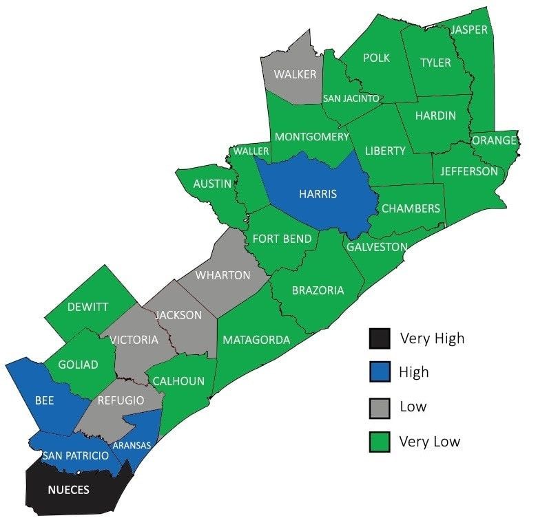 Figure 4. Hazard Risk Awareness index across the counties in southeast Texas affected by hurricane Harvey (Source: Karimiziarani et al. 2022) 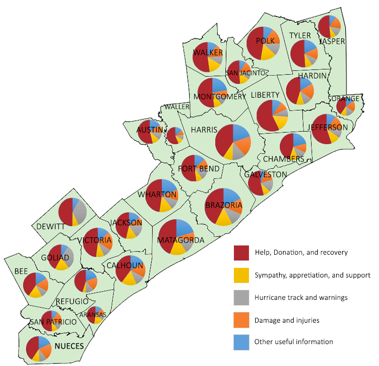 Figure 6. Categorized tweets into humanitarian classes across the counties affected by Hurricane Harvey (Source: Karimiziarani et al. 2022) Our new paper on perceptions of sea level rise has been published in Climatic Change (Impact factor: 4.743). Below please find the abstract: "Sea level rise (SLR) in the 21st century poses fundamental risks to coastal residents. The U.S. Gulf of Mexico Coast (Gulf Coast) is among the regions experiencing the most rapid relative SLR. Beyond its increasing exposure to SLR and related coastal flooding, the Gulf Coast is home to a large population and displays high social vulnerability. How the coastal population in this vulnerable region perceives the impending risks posed by SLR warrants further examination. Do coastal residents’ perceptions of SLR conform to the scientific projections? We adopt an integrative approach based on a 2019 survey merged with contextual data including percentage of population living within the Special Flood Hazard Area (SFHA) and social vulnerability at the county level, both of which are extracted from the Centers for Disease Control and Prevention. We find that public risk perceptions of sea level change are influenced by political predisposition, with Republicans being less likely than Democrats to expect SLR in the future. Moreover, SLR remains temporally distant issue among coastal residents. We then directly compare public expectations and scientific estimations of SLR in five states of the U.S. Gulf Coast region and find that coastal residents in states that have experienced faster SLR in the past are more optimistic about future SLR by underestimating its magnitude compared to those experiencing slower SLR. Moreover, we find that people likely conflate the severity with likelihood of SLR risk. The contextual force represented by percentage of population living within the SFHA designated by the Federal Emergency Management Agency (FEMA) can significantly influence individuals’ estimations of future SLR, with higher percentages leading to higher estimates. We suspect that the SFHA has become a powerful risk communication tool that influences coastal residents’ judgments about future risk. 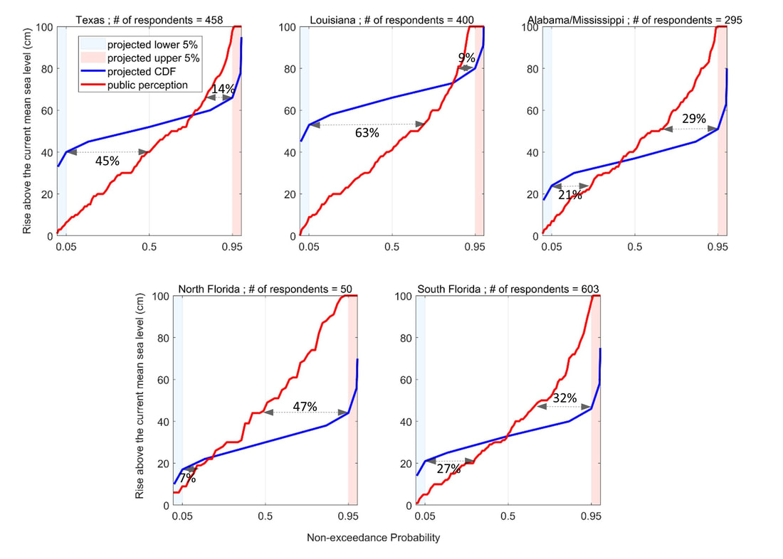 Figure 3. Comparison of public estimation with scientific estimation of SLR at five locations in Texas, Louisiana, Mississippi and Alabama, Florida Panhandle, and Florida Peninsula along the U.S. Gulf Coast. Percentages assigned at lower level and upper level in each figures represent percentages of respondents who estimated future SLR to be lower than the 5th and higher than the 95th scientific estimates, respectively (Source: Shao et al. in press). Our new paper has been published in Science of the Total Environment (Impact Factor: 7.963). Below please find the abstract: "Climate extremes will be intensified and become more frequent. One of the regions where this is the case is the U.S. Gulf coast region. This region is susceptible to the impacts of climate extremes. This region has recently experienced large amounts of economic damages caused by high-impact hurricanes and floods. Meanwhile, drought can also pose serious risks once it occurs. By using a 2019 U.S. Gulf Coast survey combined with Standard Precipitation Index, we closely examined retrospective and prospective evaluations of drought and flood among coastal residents. Drawing upon literature on human-environment system, we were interested in how the objective conditions of past drought and flood influenced individual’s perceptions of these hazards and how their retrospective evaluations were correlated with their prospective evaluations of future trends of these hazards. Coastal residents’ retrospective evaluations of past drought and flood were found to be influenced by historic objective conditions. Higher drought frequencies were found to increase the probability of perceiving increasing trend of drought number in the past. Higher flood frequencies were found to decrease the probability of perceiving increasing trend of flood number in the past. Higher intensities of drought and flood were found to increase the probabilities of perceiving increasing trends of drought duration and flood amount in the past. Coastal residents’ prospective evaluations of future drought and flood were found to be influenced by retrospective evaluations of these hazards, suggesting the temporal continuity in human judgement. Moreover, those who relied on a longer time span in reference to the future were found to be more likely to perceive increasing trends of drought and flood. We ended this paper by proposing a theoretical framework to guide future studies and discussing policy implications." 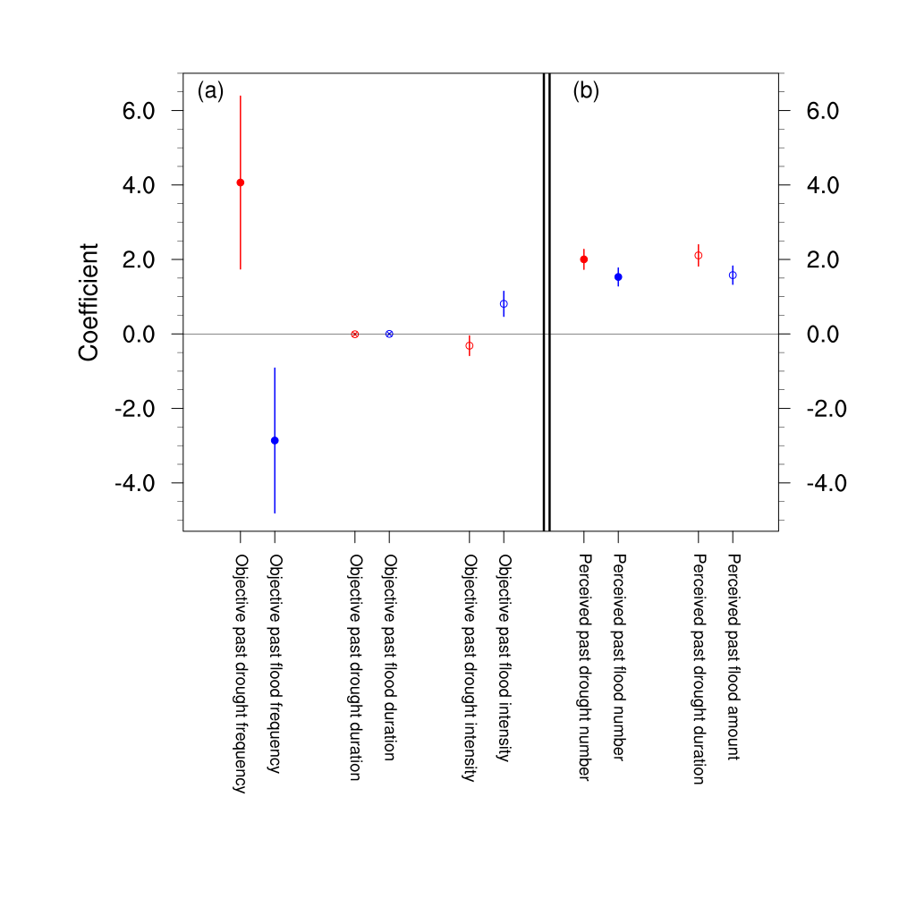 Core Figure - Figure 4. Retrospective evaluations of drought and flood risk and association with objective conditions (a) and their correlations with prospective evaluations of drought and flood risk (b). In (a), filled circles, circles with cross, empty circles depict the frequency, duration, intensity, respectively, of drought (red) and flood (blue). In (b) filled (empty) circles depict retrospective evaluations on past drought and flood numbers (past drought duration and past flood amount). The bars represent confidence intervals of all the estimated coefficients (Shao and Kam, 2020) 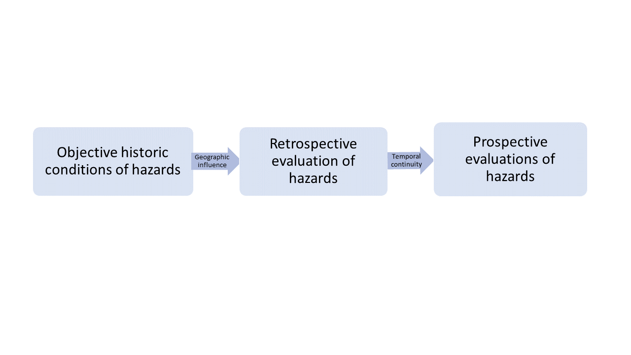 Graphic Abstract 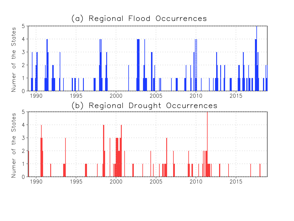 Figure 2. Number of states under regional drought events (red) and regional pluvial flood events (blue) (Shao and Kam, 2020)  Figure 3: Monthly time series of the relative search activity indices on drought (a) and flood (b) between 2004 through 2018. Dark (light) lines depict the averages (maximum and minimum values) of the relative search activity indices over the five Gulf costal states (Shao and Kam, 2020) |

|

 RSS Feed